LATEST NEWS
Technology, Instruments
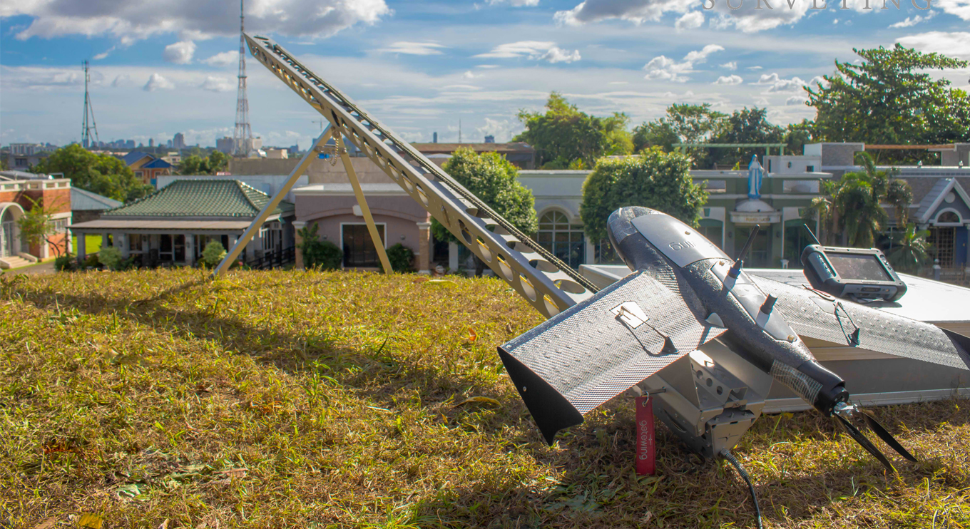
UAV Aerial Drone Mapping Solution in Philippines
Instruments
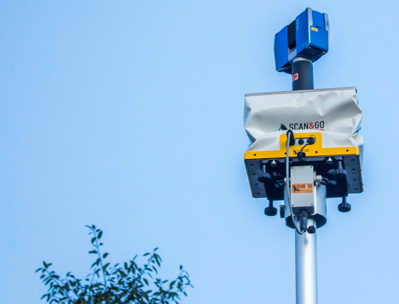
Scan & Go System

News, Training
Newly Acquired Airborne Laser Scanner
News, Events
Concrete and Steel Technology Engineering and Design

News, Instruments
Go-Anywhere 3D Mobile Mapping Solution
𝗣𝗿𝗲𝗰𝗶𝘀𝗶𝗼𝗻 𝗶𝗻 𝗠𝗼𝘁𝗶𝗼𝗻: 𝗨𝗻𝗹𝗼𝗰𝗸𝗶𝗻𝗴 𝗙𝗮𝘀𝘁𝗲𝗿, 𝗦𝗺𝗮𝗿𝘁𝗲𝗿 𝗖𝗼𝗻𝗻𝗲𝗰𝘁𝗶𝘃𝗶𝘁𝘆 𝗶𝗻 𝗖𝗲𝗻𝘁𝗿𝗮𝗹 𝗟𝘂𝘇𝗼𝗻
The Central Luzon Link Expressway (CLLEX) is designed to enhance regional mobility by strengthening connectivity between the provinces of Tarlac and Nueva Ecija. Spanning over 30 kilometers, the expressway enables faster travel, improved accessibility, and more efficient movements–supporting economic growth and development of regions.
#RASASurveying #PrecisionTechnology #ProvenExpertise #RASAOnTheGround #SurveyWithRASA #CentralLuzonLinkExpressway #CLLEX #InfrastructurePH #EngineeringExcellence #SmartMobility #RegionalGrowth #NationBuilding #FutureInfrastructure
... See more
The Central Luzon Link Expressway (CLLEX) is designed to enhance regional mobility by strengthening connectivity between the provinces of Tarlac and Nueva Ecija. Spanning over 30 kilometers, the expressway enables faster travel, improved accessibility, and more efficient movements–supporting economic growth and development of regions.
#RASASurveying #PrecisionTechnology #ProvenExpertise #RASAOnTheGround #SurveyWithRASA #CentralLuzonLinkExpressway #CLLEX #InfrastructurePH #EngineeringExcellence #SmartMobility #RegionalGrowth #NationBuilding #FutureInfrastructure
Because caring goes beyond the work we do—and every life truly matters.
Through RASA CARES CSR Initiatives, we are honored to support the patients and frontliners of UP Health Service by providing essential medical equipment that helps strengthen care, improve comfort, and protect lives. From 2 sets of hospital beds, 1 ambulance stretcher, 1 unit of BP with stand roll by, 100 bottle of dextrose, 1 unit of oxygen regulator, 2 wheelchairs, 10 oxymeter and 4 pairs of crutches, every donation reflects our commitment to community, compassion, and service.
This is our commitment beyond business: to serve communities with heart, purpose, and responsibility—giving back where it matters most.
Together, we care. Together, we give back.
#RASASurveying #RASACares #RASAGivesBack #CSRInitiatives #HealthcareWithCompassion #CommunityCare #ServingWithPurpose #UPHealthService
... See more
Through RASA CARES CSR Initiatives, we are honored to support the patients and frontliners of UP Health Service by providing essential medical equipment that helps strengthen care, improve comfort, and protect lives. From 2 sets of hospital beds, 1 ambulance stretcher, 1 unit of BP with stand roll by, 100 bottle of dextrose, 1 unit of oxygen regulator, 2 wheelchairs, 10 oxymeter and 4 pairs of crutches, every donation reflects our commitment to community, compassion, and service.
This is our commitment beyond business: to serve communities with heart, purpose, and responsibility—giving back where it matters most.
Together, we care. Together, we give back.
#RASASurveying #RASACares #RASAGivesBack #CSRInitiatives #HealthcareWithCompassion #CommunityCare #ServingWithPurpose #UPHealthService
𝗕𝗖𝗜𝗕: 𝗣𝗶𝗼𝗻𝗲𝗲𝗿𝗶𝗻𝗴 𝘁𝗵𝗲 𝗟𝗶𝗻𝗸 𝗕𝗲𝘁𝘄𝗲𝗲𝗻 𝗖𝗲𝗻𝘁𝗿𝗮𝗹 𝗟𝘂𝘇𝗼𝗻 𝗮𝗻𝗱 𝗖𝗔𝗟𝗔𝗕𝗔𝗥𝗭𝗢𝗡
The Bataan–Cavite Interlink Bridge (BCIB) will be the first direct connection between Central Luzon and CALABARZON. By providing a seamless sea-crossing, it eliminates the need for long land routes or ferry transfers, creating faster, more efficient links between two of the country's key economic regions.
With 30 years of experience, RASA Surveying ensures every pier, span, and foundation of the bridge is precisely positioned, helping bring this landmark infrastructure to life and bringing development opportunities to communities across Luzon
#RASASurveying #PrecisionTechnology #ProvenExpertise #RASAOnTheGround #SurveyWithRASA #BataanCaviteInterlinkBridge #BCIB #InfrastructurePH #EngineeringExcellence #ManilaBay #SmartMobility #RegionalGrowth #NationBuilding #FutureInfrastructure
... See more
The Bataan–Cavite Interlink Bridge (BCIB) will be the first direct connection between Central Luzon and CALABARZON. By providing a seamless sea-crossing, it eliminates the need for long land routes or ferry transfers, creating faster, more efficient links between two of the country's key economic regions.
With 30 years of experience, RASA Surveying ensures every pier, span, and foundation of the bridge is precisely positioned, helping bring this landmark infrastructure to life and bringing development opportunities to communities across Luzon
#RASASurveying #PrecisionTechnology #ProvenExpertise #RASAOnTheGround #SurveyWithRASA #BataanCaviteInterlinkBridge #BCIB #InfrastructurePH #EngineeringExcellence #ManilaBay #SmartMobility #RegionalGrowth #NationBuilding #FutureInfrastructure
ABOUT RASA


STRATEGIC GLOBAL PARTNERS


